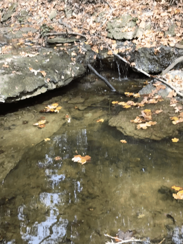
My research focuses on different aspects of human impact on water landscapes ranging from small urban creeks to medium and larger rivers in different types of landscapes. I use a variety of methods to analyze the human impact and spatio-temporal changes in water systems at multiple scales. For example, restoration of an urban stream (Klingle Creek) in Washington DC and Kali Bein rivulet in India (Punjab State) are two of my recent projects. Thematically, I work on processes such as water sustainability of India, effects of intensive agriculture on ground water, sustainability of river landscape to restoration initiatives, changes in river morphology due urbanization, rates of stream bank erosion, rates of silting in small dam reservoirs, and effects of mosses as new alternatives for erosion control.
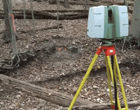
In terms of research methods, I specialize in the application of GIS and terrestrial remote sensing on water systems such as developing riverscapes for high resolution process analysis, rates and patterns of stream bank erosion, interaction of unconventional riparian vegetation with stream banks, river response to urbanization, urban river restoration, and effects of small dams. I believe that terrestrial remote sensing while offering unimaginable spatial resolution also allows innovative experimental research on water resources. One of my recent research projects involves elaborate biogeomorphic (actually bryo-geomorphic) field experiments with extensive application of terrestrial remote sensing over time. While having research projects in different parts of the United States, I also have a strong international component in my research which includes Shiwalik foot-hills of India and different parts of Punjab state in India. My collaborators include scholars from biology, geology, hydrology, agricultural engineering, civil/environmental engineering, agricultural geography, population geography, and social geography. One of the most rewarding aspects of my research is the opportunity to work closely with my students at undergraduate as well as graduate level.
In terms of research methods, I specialize in the application of GIS and terrestrial remote sensing on water systems such as developing riverscapes for high resolution process analysis, rates and patterns of stream bank erosion, interaction of unconventional riparian vegetation with stream banks, river response to urbanization, urban river restoration, and effects of small dams. I believe that terrestrial remote sensing while offering unimaginable spatial resolution also allows innovative experimental research on water resources. One of my recent research projects involves elaborate biogeomorphic (actually bryo-geomorphic) field experiments with extensive application of terrestrial remote sensing over time. While having research projects in different parts of the United States, I also have a strong international component in my research which includes Shiwalik foot-hills of India and different parts of Punjab state in India. My collaborators include scholars from biology, geology, hydrology, agricultural engineering, civil/environmental engineering, agricultural geography, population geography, and social geography. One of the most rewarding aspects of my research is the opportunity to work closely with my students at undergraduate as well as graduate level.
Research Interests
- GIS applications in water resources
- High resolution terrestrial LiDAR and point cloud applications in developing riverscapes
- Stream bank erosion and riparian vegetation
- Applied geomorphology
- Urban river restoration
- River response to urbanization
- Effects of intensive irrigation on ground water level in South Asia
- Geomorphic and social effects of small dams
- Coupled human environment systems
Projects
- Using mosses for controlling stream bank erosion (Terrestrial Remote Sensing + Fluvial Geomorphology + Plant Biology). Funded by the National Science Foundation.
- Developing riverscapes with terrestrial remote sensing (Terrestrial Remote Sensing + Fluvial Geomorphology)
- Effects of small dams (Fluvial Geomorphology + Terrestrial Remote Sensing + Social Geography). Funded by the National Science Foundation. Weblink: http://shiwalikcheckdams.weebly.com/ . Field Video: https://youtu.be/NRGz6TRnL_I
- Urban river restoration (Terrestrial Remote Sensing + Fluvial Geomorphology + Sociology + Public Policy)
- Geomorphic effects of urbanization (Fluvial Geomorphology + Urban Geography + Economics)
- Applied geomorphology
- Using point cloud to quantify channel change due to wood debris (Terrestrial Remote Sensing + Fluvial Geomorphology). Funded by United States Department of the Interior - Bureau of Land Management
- Sustainable water resource management (Geospatial Modeling + Remote Sensing + Water Conservation)
- Parking lots as avenues for ecological resilience of urbanization- a hydrological, geomorphic, atmospheric and sociological analysis (Collaborations: Geomorphology + Hydrology + Meteorology + Sociology)
- Geomorphic and social analysis of public involvement in the conservation of local streams: a case study of road versus river dispute in the Klingle Valley of Washington DC (Collaborations: Geomorphology + Sociology)
- Spatial pattern of ground water level changes in relations to intensive irrigation agriculture in Central Punjab, India (Collaborations: Geomorphology + Agricultural Geography)
- Trends and feedbacks of disappearing wetlands in the rural areas of Central Punjab, India (Collaborations: Geomorphology + Agricultural Geography)
Selected Publications
- Kang, R.S., (2020) “Saving an Impacted Sacred River of Punjab (India) with the Help of a Volunteer Sikh Religious Community,” Focus (June 6, 2020). Weblink: http://www.focusongeography.org/publications/articles/river_of_punjab/index.html?fbclid=IwAR1FAfjKl8uWEF7jb9feI7TOSbi7hlI_og-cdCF92mvpC44lDyJFoYfxtrA
- Kang, R.S., Chacko, E., Kaur, D., Viadero, R. (2019) “Silting Patterns in the Reservoirs of Small- and Medium-Sized Earthen Check Dams in Humid Subtropical Monsoon Regions,” Earth Surface Processes and Landforms 44 (13): 2638-2648. Weblink: https://onlinelibrary.wiley.com/doi/10.1002/esp.4689
- Vitt, D. H., Melissa, H., Kang, R.S. (2018). The stability of moss populations on stream banks along two first order, temperate-forest, headwater streams, The Bryologist 121 (2). Weblink: http://www.bioone.org/doi/pdf/10.1639/0007-2745-121.2.205
- Kang, R.S., Kaur, D. (2018). Spatial pattern of ground water level changes in the irrigated agricultural region of Bist Doab, Punjab, India, Singapore Journal of Tropical Geography 39 (1): 75-89. Weblink (full article): https://rdcu.be/bCC9o
- Kang, R.S., (2014). Geomorphic characteristics of riffle-pool spacing in a low order stream with high rates of bank erosion in Fairfax County, Virginia. Zeitschrift für Geomorphologie 58 (4): 459-470. Weblink: https://www.schweizerbart.de/papers/zfg/detail/58/84508/
- Kang, R.S., (2012). Geomorphic effects of mosses in a low order stream in Fairfax County, Virginia. Physical Geography 33(4): 360-382. Weblink: http://www.tandfonline.com/doi/abs/10.2747/0272-3646.33.4.360#.VF6yTMn4plk
- Kang, R.S., Storm, D., and Marston, R.A., (2010). Downstream effects of urbanization on Stillwater Creek, Oklahoma. Physical Geography 31(2): 186-201. Weblink: http://www.tandfonline.com/doi/abs/10.2747/0272-3646.31.2.186#.VF60Lsn4plk
- Kang, R.S., and Marston, R.A., 2006. (cited in 22 research publications) Geomorphic effects of rural-to-urban land use conversion on three streams in the Central Redbed Plains of Oklahoma. Geomorphology 79(3-4): 488-506. Also published in Proceedings of the Binghamton Symposium in Geomorphology: The Human Role in Changing Fluvial Systems, James, A.L. and Marcus, W.A. (eds.), No. 37, Elsevier: Amsterdam, NETH, 506. Weblink: https://www.sciencedirect.com/science/article/pii/S0169555X06002649
- Storm, D.E., White, M.J., Brown, G.O., Smolen, M.D., and Kang, R.S., 2006. Protocol to determine the optimal placement of riparian/buffer strips in watersheds. Final Report Submitted to Oklahoma Water Resources Research Institute and the United States Geological Survey.
External Grants
- United States Department of the Interior-Bureau of Land Management, Since 2016 ($25,000): Geomorphic effects of woody debris jams on channel morphology and stream bank erosion in Thompson Creek (Lorton, VA), Kang R.S. (PI: $25,000)
- NSF-Geography and Spatial Sciences, Since 2015 ($312,478): Geomorphic and Ecological Analysis of Using Mosses for Controlling Stream Bank Erosion, Kang R.S. (PI: $235,764) & Vitt, D. (CoPI- University of Southern Illinois, Carbondale: $76,714). Proposal # 1461773
- NSF-Catalyzing New International Collaborations, 2013-2015 ($30,016): Geomorphic and Social Impacts of Check Dams: Planning Visit to the Eco-sensitive Shiwalik Foothills of India, Kang R.S. (PI: $16,291) with Chacko, E (CoPI from The George Washington University: $13,725). Proposal # 1338763